TZMAP9 9" Chartplotter Fishfinder


Complete Your Purchase


Furuno TZMAP9 9" Chartplotter Fishfinder
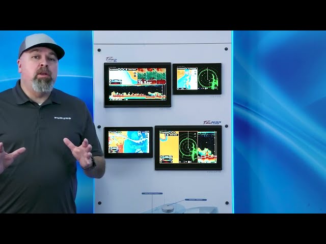
The Furuno TZMAP9 is a powerful stand-alone marine multifunction display designed for boaters who demand premium navigation and fish-finding capabilities in a compact, simplified package. Featuring a 9-inch color multi-touch LCD, the TZMAP9 delivers responsive, intuitive control over charts, sonar, and system settings without the need for a complex network system. Operating on a standard 12–24V DC supply, the unit supports selectable sonar power output of 300W, 600W, or 1kW, bringing proven Furuno performance to a wide range of vessels.
At the heart of the TZMAP9 is the TZ MAPS cartography platform, which allows users to download and work with high-detail chart data including satellite imagery, bathymetric coverage, and customizable depth shading. The unit can display TZ MAPS 3D data, CMOR, raster, vector, and satellite photo chart types. BathyVision for TZ MAPS delivers off-the-charts bathymetric data with contour lines configurable down to a resolution of just 3 inches between contours — 3x better resolution than other bathymetric chart services. The intuitive touch interface mirrors modern smart-device controls, making panning, zooming, and feature selection simple under all lighting conditions.
Navigation capabilities include cloud-based backup and retrieval of waypoints and routes through a free TimeZero account, ensuring critical data remains safe and portable. Users can create custom chart objects such as buoys or notations and share them with other registered TZ MAPS users. AI routing intelligently plans routes considering the boat's draft, charted depths, and navigational obstacles. Purchasing any TZ MAPS chart area also unlocks that chart in the free TZ iBoat app for mobile devices, providing a home-planning companion.
Built-in TruEcho CHIRP or CW fish-finding technology provides Furuno's legendary detection and detail for marking fish and scanning structure throughout the water column. The integrated CHIRP Side-Scan sonar scans both port and starboard at center frequencies of 230 kHz or 445 kHz, compatible with thru-hull, paired, or transom-mount transducer options. Side-Scan imagery can be viewed in eight color palettes including Tuna Hunter, Volcano, and Fury.
The TZMAP9 is radar-compatible with Furuno DRS4DL+, DRS2DNXT, and DRS4DNXT dome radars, enabling features like Target Analyzer, Fast Target Tracking, Bird Mode, and Rain Mode for enhanced situational awareness. TZ Weather delivers free global and regional weather predictions from NOAA's Global Forecast System (GFS), with premium subscription options for higher-resolution models. Dynamic Mooring integrates real-time weather forecasts with TZ MAPS mapping to automatically analyze wind conditions and topography, providing color-coded mooring status for safe anchorage selection.
Key Features
- Built-in TruEcho CHIRP or CW sonar with 300W, 600W, or 1kW power output
- 9-inch color multi-touch LCD display
- TZ MAPS cartography platform with satellite imagery, bathymetric data, and BathyVision
- Built-in CHIRP Side-Scan at 230 kHz or 445 kHz center frequencies
- Preloaded NOAA Vector Charts for the entire US coastal area
- Cloud-based waypoint and route backup via free TimeZero account
- AI routing with TZ iBoat mobile app integration
- Radar compatible with Furuno DRS4DL+, DRS2DNXT, and DRS4DNXT
- TZ Weather global forecasting and Dynamic Mooring anchorage analysis
- CMOR, raster, vector, satellite photo, and 3D chart support
- Includes protective cover, power cable, mounting bracket, flush mount hardware, and cleaning cloth
- 2-year warranty

You May Also Like


