New
Furuno TZT13E Multi-Function Display Fishfinder/Chartplotter
Model #
24211625
Mfg #
TZT13E
$3,095.00
Orders placed by 3 PM EST typically ship the same day. Orders placed after this time will be processed the next business day.


New
Furuno TZT13E Multi-Function Display Fishfinder/Chartplotter
Model #
24211625
Mfg #
TZT13E
$3,095.00
Out Of Stock
Item out of stock get notified when back in stock:
Thank you!
We'll let you know when it's back in stock.
Quantity not available. Please adjust.
−
+
Complete Your Purchase

 Transducer - SideScan Fish Reveal")


Furuno TZT13E Multi-Function Display Fishfinder/Chartplotter
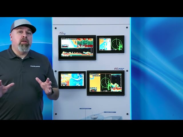
The Furuno NavNet TZtouch E Series delivers serious performance and system scalability to vessels of any size. The TZT13E goes beyond stand-alone navigation with full Radar compatibility, Sonar expandability, and integration with cameras, IP devices, and other sensors. Built-in TruEcho CHIRP™ Fish Finder, CHIRP Side-Scan, and TZ MAPS support come standard, providing a powerful suite of navigation tools in a clean, compact 13-inch design powered by the intuitive TZtouchXL platform.
Key Features
- Effortless Control: The most intuitive UI available — edge-swipe features and single-tap menu options mean you're never more than a tap or swipe away from what you need. If you can swipe a phone, you can operate TZtouchXL.
- TZ MAPS: Download wide chart areas, satellite photos, and bathymetric data directly from the MFD. Custom depth color shading and overlays create charts of unmatched detail. AI Routing intelligently plans routes considering the boat's draft, charted depths, and navigational obstacles.
- BathyVision: Off-the-charts bathymetric data with contour lines configurable down to a resolution of 3 inches between contours — 3x better than any other bathymetric chart on the market.
- TZ Weather: Enhanced situational awareness with free global and regional weather predictions from NOAA's Global Forecast System (GFS). Premium subscription unlocks higher-resolution data from ICON, NAM CONUS, Arpège, and AROME models.
- Dynamic Mooring: Integrates real-time weather forecasts with TZ MAPS to analyze wind conditions and topography, providing color-coded mooring status (green/orange/red) for safe anchorage selection.
- Benchmark Radar Integration: Compatible with X-Class magnetron and NXT Solid-State Doppler Radar models. Features Target Analyzer™, Fast Target Tracking, Bird Mode, Rain Mode, Risk Visualizer™, and AI Avoidance Route™.
- Risk Visualizer™ & AI Avoidance Route™: Risk Visualizer™ assesses all objects 360° around the vessel and creates dynamic collision-risk icons. AI Avoidance Route™ uses Radar data and TZ MAPS to instantly determine a safe route around hazards.
- Built-In CHIRP Side-Scan: Scans both port and starboard at 230kHz or 445kHz center frequencies, illuminating bottom structure in high definition. Available in 8 color presentations including Tuna Hunter, Volcano, and Fury palettes. Compatible with thru-hull, paired, or transom mount transducer options.
- TruEcho™ CHIRP Fish Finder: Built-in 300W/600W/1kW TruEcho™ CHIRP or CW Fish Finder alongside built-in 230kHz or 455kHz CHIRP Side-Scan for detailed port-to-starboard fish and structure imaging.
- TZ Cloud: Create routes at home using TZ Navigator, a web browser, or the TZ iBoat iOS App, then sync to the MFD from the cloud. Waypoints, routes, boundaries, photos, and catch data are backed up automatically and securely.

Cartography
Furuno
Diagonal Screen Size
13"
Display Type
Color Multi-Touch LCD
Frequency
CW 50-200kHz
,
CHIRP 40kHz to 225kHz
GPS
Yes
Maximum Range
1200
Sonar
CHIRP Fish Finder
,
CHIRP Side-Scan
Transducer Included
No
Voltage
12-24 VDC
Wattage
1000
You May Also Like
New

New

New

New

New


